
Cities are updating their strategy for deploying smart, connected technology in the Public Right Of Way (ROW). Understanding how technology, combined with data, and engineering could redesign, augment or replace to create the City’s next-generation streetscape is critical in answering how the cities can meet its End Policies related to Public Safety, High Performing Government, Economic Development, and Financial Stability. Part of the efforts is identifying (1) which improved services can be delivered with (2) what smart technology that is deployed on (3) which City assets, and (4) funded by what business models.
In this post, we are proposing a connected vehicle idea applicable to the Public Works Fleet and similar deployments (the “Connected Fleet”). The Connected Fleet Weather Monitoring for Road Safety Management is a Smart City solution that falls in the Public Safety, and High Performing Government buckets, as well as Facility Maintenance. This solution can be extended to deliver the Exceptional City Services goal. This solution can be integrated with Connected Fleet Telematics for Cost-Effective Operations. The augmented solution address the Public Safety related to Traffic Safety and Exceptional City Services.
The Use Case
In the wintertime, some cities experience notorious winter conditions. To keep the roads open and safe during severe winter weather, require making better decisions about deploying road crews, and the proper mix of material for snow management. Ambient temperature is not the proper metric for preparing the salt and chemical mix, as well as their quantities. Snowplowing trucks may not have the right mix or check the sensors. With no preplanning information at the snow management center, the result is delayed snow management which impacts commute time, travelers’ safety, material waste, the adverse impact of excessive chemical contents on habitats and groundwater contamination.
To be able to pull the road and weather conditions to the snow management center, Road Weather Information System (RWIS) could provide the much-needed data. These fixed stations include scientific-grade weather instrumentation. RWIS stations collect, transmit and disseminate weather and road condition information. The instrumentation measures road surface and sub-surface temperatures, road state (dry, wet, snow, ice), wind speed and direction, liquid precipitation (amount, occurrence, type), humidity and visibility. Data transmission and communication is governed by the Intelligent Transportation System (ITS) standard. However, RWIS are relatively expensive, typically starting at $125,000 per unit. Federal, state and local government transportation budgets are not accommodating the road observation density needed to improve the road condition situational awareness and treatment methods.
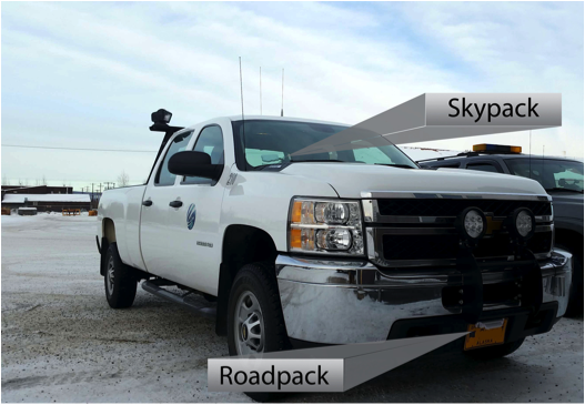
This gap in capability can be addressed by mobile sensing technologies and instrumentation that can be installed directly on fleet vehicles. Communication is provided through wireless communication method via an embedded SIM card on the sensors pack, or BlueTooth interfaces to move data packets through on-board vehicle communication. The data transmitted to the cloud to make better ground-level decisions. Thus, the CITY can be proactive in saving lives and significantly reducing road maintenance costs.
The Value
As population growth surges, the number of cars on our roads worldwide is expected to double by 2040. The challenges of ensuring citizens have affordable, efficient and sustainable transportation are immense. Having access to real-time, actionable road weather information is an essential component of optimizing mobility for road users. Advance knowledge of how the weather will impact a city’s mission-critical services can save a city millions in reduced overtime hours and better asset management. The solution can significantly enhance the CITY snow management operator’s ability to accurately predict and manage winter weather extremes. This includes:
- Prepare city response to adverse weather well in advance
- Reduce unnecessary overtime hours for critical city services
- Optimize the deployment of maintenance equipment and materials
- Limit weather-related delays on city transport routes
- Increase citizen safety
The value proposition is creating safer roads for drivers utilizing the Internet of Things sensor technology and machine learning forecast algorithm.
- High-resolution Ground Truth road condition forecasts to offer better situational awareness around severe weather and other safety thresholds (e.g., slick roads, slick walkways, black ice, temperature extremes, low visibility, etc)
- Advance warning through public alerts on high-threat areas to avoid and re-route options
- Safer roads and sidewalks and Smart treatment applications to maintain smart corridor safety and prevent ice build-up and personal injury
- Lower costs and enhanced safety through more efficient, optimized road and walkway maintenance
- Adaptive traffic flow and light sequence as adverse weather affects road conditions and congestion through the corridor
Furthermore, the Hyper-local road weather data can be merged with additional data sets, such as traffic or road maintenance data, to optimize routing and reduce travel time. The solution benefits could be extended in a connected vehicle environment to support automated alerting with vehicle data share.